A Quick PHOTO JOURNEY from our recent Road-Journey from Jammu to Shri-Nagar through Old Mughal Road

Basically this journey started from Delhi to Shrinagar with Nitin in his Gypsy, but this Photo Journey shares some of the photographs clicked on Mughal Road which connects Jammu with Shrinagar through Rajouri. Let's check out some of the photographs from beautiful hills of Jammu&Kashmir...Top photograph was clicked in famous lake of Shrinagar - Dal Lake. This lady was coming to Dal-lake market from her house, which was around the corner of dal-lake. It was amazing to see people riding their own boats/shikara in Dal lake to reach markets or other important places. We shall be sharing a detailed Photo Journey on Dal LakeHere is a photograph of shopkeeper at Pir-ki-Gali. He had a very small shop in the middle of a high hill. It was windy and chilly outside, so he was sitting inside the shop which was closed from all sides with a small hole open for entry. He was not a resident of this place. It seems many families come to higher hills with their cattle during summers and he was the one to serve their basic needs. There were few other houses made up of stones, but spaced out in wide valleys around these hillsHorses grazing grass on green hills around Mughal Road. You can see the old Mughal road in the center of this photograph. J&K government is developing this road and it's in good shape, although work in few patches is still on. It can be one of the other main tourist circuits in Jammu & Kashmir.Goats crossing through snow capped hills of Jammu & Kashmir state of India. This photograph is shot around Sinthan Pass which is connected to Shrinagar through Anantnag. Goats and sheep can be seen in huge number on these hills, during summers. Most of these folks some up from their towns due to abundance of feed on these green hills. They also have temporary shelters where they spend few months and then go back to their main residence during snowfall. A little girl walking towards the village through lush-green paddy fields @ Jammu and Kashmir, India.This photograph was shot while we were coming back to Shrinagar from Sinthan Pass... There are very beautiful villages and towns on this way with amazing water-streams all over the place. There were very good security arrangements on most of the hills around Mughal Road. All happy faces taking all the pain to make us feel secure. This photograph is again clicked around Peer-ki-Gali... We also spent some time with these folks over a cup of tea...Moghul Road is the road between Bafliaz, a town in the Poonch district, to Shopian district in the Kashmir valley. The road is 84km long and situated in the Jammu and Kashmir state of India. It passes over Pir Panjal Mountain range, at altitude of 11500 feet, that is higher than Banihal pass.Mughal road brings the Poonch and Rajouri district closer to Srinagar in Kashmir valley. The distance between Srinagar and Poonch will be reduced from 588km to 126km. It makes for alternate road route to Kashmir valley from rest of India, other than over-crowded Jammu-Srinagar Highway through Jawahar Tunnel (Banihal Tunnel) (National Highway 1A). The road passes through Buffliaz, Poshana, Chattapani, Peer Ki Gali, Aliabad, Zaznar, Dubjan, Heerpora and Shopian.Mughal road was historically used by Moghul emperors to travel and conquer Kashmir during the sixteenth century. It was the route used by Akbar the Great to conquer Kashmir in 1586, and his son Emperor Jahangir died while returning from Kashmir on this road near Rajouri.The construction of this prestigious project was started in 2005 with a target of completion in March 2007 and an estimated cost of INR 255 crores. Mughal road cuts through Hirpora wildlife sanctuary. Initially, there was opposition to the construction of the road because it would fragment the wildlife and inhibit movement of animals, especially the endangered Markhor goat in the region. Also, opponents claimed the road will get early snowfall in winter and hence will not serve as an alternate route to existing Jammu-Srinagar highway. Finally Supreme Court gave conditional permission for the construction of the road. There is great progress on this road, although some parts of it are under maintenancAfter tiring journey from Delhi to Shrinagar, it was time to go out for Shikara-ride in Dal Lake of Shrinagar. This photograph is shot from a beautiful shikara, while we were relaxing on cushioned bed.

 Basically this journey started from Delhi to Shrinagar with Nitin in his Gypsy, but this Photo Journey shares some of the photographs clicked on Mughal Road which connects Jammu with Shrinagar through Rajouri. Let's check out some of the photographs from beautiful hills of Jammu&Kashmir...

Top photograph was clicked in famous lake of Shrinagar - Dal Lake. This lady was coming to Dal-lake market from her house, which was around the corner of dal-lake. It was amazing to see people riding their own boats/shikara in Dal lake to reach markets or other important places. We shall be sharing a detailed Photo Journey on Dal Lake.

Basically this journey started from Delhi to Shrinagar with Nitin in his Gypsy, but this Photo Journey shares some of the photographs clicked on Mughal Road which connects Jammu with Shrinagar through Rajouri. Let's check out some of the photographs from beautiful hills of Jammu&Kashmir...Top photograph was clicked in famous lake of Shrinagar - Dal Lake. This lady was coming to Dal-lake market from her house, which was around the corner of dal-lake. It was amazing to see people riding their own boats/shikara in Dal lake to reach markets or other important places. We shall be sharing a detailed Photo Journey on Dal LakeHere is a photograph of shopkeeper at Pir-ki-Gali. He had a very small shop in the middle of a high hill. It was windy and chilly outside, so he was sitting inside the shop which was closed from all sides with a small hole open for entry. He was not a resident of this place. It seems many families come to higher hills with their cattle during summers and he was the one to serve their basic needs. There were few other houses made up of stones, but spaced out in wide valleys around these hillsHorses grazing grass on green hills around Mughal Road. You can see the old Mughal road in the center of this photograph. J&K government is developing this road and it's in good shape, although work in few patches is still on. It can be one of the other main tourist circuits in Jammu & Kashmir.Goats crossing through snow capped hills of Jammu & Kashmir state of India. This photograph is shot around Sinthan Pass which is connected to Shrinagar through Anantnag. Goats and sheep can be seen in huge number on these hills, during summers. Most of these folks some up from their towns due to abundance of feed on these green hills. They also have temporary shelters where they spend few months and then go back to their main residence during snowfall. A little girl walking towards the village through lush-green paddy fields @ Jammu and Kashmir, India.This photograph was shot while we were coming back to Shrinagar from Sinthan Pass... There are very beautiful villages and towns on this way with amazing water-streams all over the place. There were very good security arrangements on most of the hills around Mughal Road. All happy faces taking all the pain to make us feel secure. This photograph is again clicked around Peer-ki-Gali... We also spent some time with these folks over a cup of tea...Moghul Road is the road between Bafliaz, a town in the Poonch district, to Shopian district in the Kashmir valley. The road is 84km long and situated in the Jammu and Kashmir state of India. It passes over Pir Panjal Mountain range, at altitude of 11500 feet, that is higher than Banihal pass.Mughal road brings the Poonch and Rajouri district closer to Srinagar in Kashmir valley. The distance between Srinagar and Poonch will be reduced from 588km to 126km. It makes for alternate road route to Kashmir valley from rest of India, other than over-crowded Jammu-Srinagar Highway through Jawahar Tunnel (Banihal Tunnel) (National Highway 1A). The road passes through Buffliaz, Poshana, Chattapani, Peer Ki Gali, Aliabad, Zaznar, Dubjan, Heerpora and Shopian.Mughal road was historically used by Moghul emperors to travel and conquer Kashmir during the sixteenth century. It was the route used by Akbar the Great to conquer Kashmir in 1586, and his son Emperor Jahangir died while returning from Kashmir on this road near Rajouri.The construction of this prestigious project was started in 2005 with a target of completion in March 2007 and an estimated cost of INR 255 crores. Mughal road cuts through Hirpora wildlife sanctuary. Initially, there was opposition to the construction of the road because it would fragment the wildlife and inhibit movement of animals, especially the endangered Markhor goat in the region. Also, opponents claimed the road will get early snowfall in winter and hence will not serve as an alternate route to existing Jammu-Srinagar highway. Finally Supreme Court gave conditional permission for the construction of the road. There is great progress on this road, although some parts of it are under maintenancAfter tiring journey from Delhi to Shrinagar, it was time to go out for Shikara-ride in Dal Lake of Shrinagar. This photograph is shot from a beautiful shikara, while we were relaxing on cushioned bed.

Here is a photograph of shopkeeper at Pir-ki-Gali. He had a very small shop in the middle of a high hill. It was windy and chilly outside, so he was sitting inside the shop which was closed from all sides with a small hole open for entry. He was not a resident of this place. It seems many families come to higher hills with their cattle during summers and he was the one to serve their basic needs. There were few other houses made up of stones, but spaced out in wide valleys around these hills.

Basically this journey started from Delhi to Shrinagar with Nitin in his Gypsy, but this Photo Journey shares some of the photographs clicked on Mughal Road which connects Jammu with Shrinagar through Rajouri. Let's check out some of the photographs from beautiful hills of Jammu&Kashmir...Top photograph was clicked in famous lake of Shrinagar - Dal Lake. This lady was coming to Dal-lake market from her house, which was around the corner of dal-lake. It was amazing to see people riding their own boats/shikara in Dal lake to reach markets or other important places. We shall be sharing a detailed Photo Journey on Dal LakeHere is a photograph of shopkeeper at Pir-ki-Gali. He had a very small shop in the middle of a high hill. It was windy and chilly outside, so he was sitting inside the shop which was closed from all sides with a small hole open for entry. He was not a resident of this place. It seems many families come to higher hills with their cattle during summers and he was the one to serve their basic needs. There were few other houses made up of stones, but spaced out in wide valleys around these hillsHorses grazing grass on green hills around Mughal Road. You can see the old Mughal road in the center of this photograph. J&K government is developing this road and it's in good shape, although work in few patches is still on. It can be one of the other main tourist circuits in Jammu & Kashmir.Goats crossing through snow capped hills of Jammu & Kashmir state of India. This photograph is shot around Sinthan Pass which is connected to Shrinagar through Anantnag. Goats and sheep can be seen in huge number on these hills, during summers. Most of these folks some up from their towns due to abundance of feed on these green hills. They also have temporary shelters where they spend few months and then go back to their main residence during snowfall. A little girl walking towards the village through lush-green paddy fields @ Jammu and Kashmir, India.This photograph was shot while we were coming back to Shrinagar from Sinthan Pass... There are very beautiful villages and towns on this way with amazing water-streams all over the place. There were very good security arrangements on most of the hills around Mughal Road. All happy faces taking all the pain to make us feel secure. This photograph is again clicked around Peer-ki-Gali... We also spent some time with these folks over a cup of tea...Moghul Road is the road between Bafliaz, a town in the Poonch district, to Shopian district in the Kashmir valley. The road is 84km long and situated in the Jammu and Kashmir state of India. It passes over Pir Panjal Mountain range, at altitude of 11500 feet, that is higher than Banihal pass.Mughal road brings the Poonch and Rajouri district closer to Srinagar in Kashmir valley. The distance between Srinagar and Poonch will be reduced from 588km to 126km. It makes for alternate road route to Kashmir valley from rest of India, other than over-crowded Jammu-Srinagar Highway through Jawahar Tunnel (Banihal Tunnel) (National Highway 1A). The road passes through Buffliaz, Poshana, Chattapani, Peer Ki Gali, Aliabad, Zaznar, Dubjan, Heerpora and Shopian.Mughal road was historically used by Moghul emperors to travel and conquer Kashmir during the sixteenth century. It was the route used by Akbar the Great to conquer Kashmir in 1586, and his son Emperor Jahangir died while returning from Kashmir on this road near Rajouri.The construction of this prestigious project was started in 2005 with a target of completion in March 2007 and an estimated cost of INR 255 crores. Mughal road cuts through Hirpora wildlife sanctuary. Initially, there was opposition to the construction of the road because it would fragment the wildlife and inhibit movement of animals, especially the endangered Markhor goat in the region. Also, opponents claimed the road will get early snowfall in winter and hence will not serve as an alternate route to existing Jammu-Srinagar highway. Finally Supreme Court gave conditional permission for the construction of the road. There is great progress on this road, although some parts of it are under maintenancAfter tiring journey from Delhi to Shrinagar, it was time to go out for Shikara-ride in Dal Lake of Shrinagar. This photograph is shot from a beautiful shikara, while we were relaxing on cushioned bed.

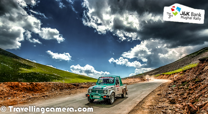
Horses grazing grass on green hills around Mughal Road. You can see the old Mughal road in the center of this photograph. J&K government is developing this road and it's in good shape, although work in few patches is still on. It can be one of the other main tourist circuits in Jammu & Kashmir.

Basically this journey started from Delhi to Shrinagar with Nitin in his Gypsy, but this Photo Journey shares some of the photographs clicked on Mughal Road which connects Jammu with Shrinagar through Rajouri. Let's check out some of the photographs from beautiful hills of Jammu&Kashmir...Top photograph was clicked in famous lake of Shrinagar - Dal Lake. This lady was coming to Dal-lake market from her house, which was around the corner of dal-lake. It was amazing to see people riding their own boats/shikara in Dal lake to reach markets or other important places. We shall be sharing a detailed Photo Journey on Dal LakeHere is a photograph of shopkeeper at Pir-ki-Gali. He had a very small shop in the middle of a high hill. It was windy and chilly outside, so he was sitting inside the shop which was closed from all sides with a small hole open for entry. He was not a resident of this place. It seems many families come to higher hills with their cattle during summers and he was the one to serve their basic needs. There were few other houses made up of stones, but spaced out in wide valleys around these hillsHorses grazing grass on green hills around Mughal Road. You can see the old Mughal road in the center of this photograph. J&K government is developing this road and it's in good shape, although work in few patches is still on. It can be one of the other main tourist circuits in Jammu & Kashmir.Goats crossing through snow capped hills of Jammu & Kashmir state of India. This photograph is shot around Sinthan Pass which is connected to Shrinagar through Anantnag. Goats and sheep can be seen in huge number on these hills, during summers. Most of these folks some up from their towns due to abundance of feed on these green hills. They also have temporary shelters where they spend few months and then go back to their main residence during snowfall. A little girl walking towards the village through lush-green paddy fields @ Jammu and Kashmir, India.This photograph was shot while we were coming back to Shrinagar from Sinthan Pass... There are very beautiful villages and towns on this way with amazing water-streams all over the place. There were very good security arrangements on most of the hills around Mughal Road. All happy faces taking all the pain to make us feel secure. This photograph is again clicked around Peer-ki-Gali... We also spent some time with these folks over a cup of tea...Moghul Road is the road between Bafliaz, a town in the Poonch district, to Shopian district in the Kashmir valley. The road is 84km long and situated in the Jammu and Kashmir state of India. It passes over Pir Panjal Mountain range, at altitude of 11500 feet, that is higher than Banihal pass.Mughal road brings the Poonch and Rajouri district closer to Srinagar in Kashmir valley. The distance between Srinagar and Poonch will be reduced from 588km to 126km. It makes for alternate road route to Kashmir valley from rest of India, other than over-crowded Jammu-Srinagar Highway through Jawahar Tunnel (Banihal Tunnel) (National Highway 1A). The road passes through Buffliaz, Poshana, Chattapani, Peer Ki Gali, Aliabad, Zaznar, Dubjan, Heerpora and Shopian.Mughal road was historically used by Moghul emperors to travel and conquer Kashmir during the sixteenth century. It was the route used by Akbar the Great to conquer Kashmir in 1586, and his son Emperor Jahangir died while returning from Kashmir on this road near Rajouri.The construction of this prestigious project was started in 2005 with a target of completion in March 2007 and an estimated cost of INR 255 crores. Mughal road cuts through Hirpora wildlife sanctuary. Initially, there was opposition to the construction of the road because it would fragment the wildlife and inhibit movement of animals, especially the endangered Markhor goat in the region. Also, opponents claimed the road will get early snowfall in winter and hence will not serve as an alternate route to existing Jammu-Srinagar highway. Finally Supreme Court gave conditional permission for the construction of the road. There is great progress on this road, although some parts of it are under maintenancAfter tiring journey from Delhi to Shrinagar, it was time to go out for Shikara-ride in Dal Lake of Shrinagar. This photograph is shot from a beautiful shikara, while we were relaxing on cushioned bed.

Goats crossing through snow capped hills of Jammu & Kashmir state of India. This photograph is shot around Sinthan Pass which is connected to Shrinagar through Anantnag. Goats and sheep can be seen in huge number on these hills, during summers. Most of these folks some up from their towns due to abundance of feed on these green hills. They also have temporary shelters where they spend few months and then go back to their main residence during snowfall. 

Basically this journey started from Delhi to Shrinagar with Nitin in his Gypsy, but this Photo Journey shares some of the photographs clicked on Mughal Road which connects Jammu with Shrinagar through Rajouri. Let's check out some of the photographs from beautiful hills of Jammu&Kashmir...Top photograph was clicked in famous lake of Shrinagar - Dal Lake. This lady was coming to Dal-lake market from her house, which was around the corner of dal-lake. It was amazing to see people riding their own boats/shikara in Dal lake to reach markets or other important places. We shall be sharing a detailed Photo Journey on Dal LakeHere is a photograph of shopkeeper at Pir-ki-Gali. He had a very small shop in the middle of a high hill. It was windy and chilly outside, so he was sitting inside the shop which was closed from all sides with a small hole open for entry. He was not a resident of this place. It seems many families come to higher hills with their cattle during summers and he was the one to serve their basic needs. There were few other houses made up of stones, but spaced out in wide valleys around these hillsHorses grazing grass on green hills around Mughal Road. You can see the old Mughal road in the center of this photograph. J&K government is developing this road and it's in good shape, although work in few patches is still on. It can be one of the other main tourist circuits in Jammu & Kashmir.Goats crossing through snow capped hills of Jammu & Kashmir state of India. This photograph is shot around Sinthan Pass which is connected to Shrinagar through Anantnag. Goats and sheep can be seen in huge number on these hills, during summers. Most of these folks some up from their towns due to abundance of feed on these green hills. They also have temporary shelters where they spend few months and then go back to their main residence during snowfall. A little girl walking towards the village through lush-green paddy fields @ Jammu and Kashmir, India.This photograph was shot while we were coming back to Shrinagar from Sinthan Pass... There are very beautiful villages and towns on this way with amazing water-streams all over the place. There were very good security arrangements on most of the hills around Mughal Road. All happy faces taking all the pain to make us feel secure. This photograph is again clicked around Peer-ki-Gali... We also spent some time with these folks over a cup of tea...Moghul Road is the road between Bafliaz, a town in the Poonch district, to Shopian district in the Kashmir valley. The road is 84km long and situated in the Jammu and Kashmir state of India. It passes over Pir Panjal Mountain range, at altitude of 11500 feet, that is higher than Banihal pass.Mughal road brings the Poonch and Rajouri district closer to Srinagar in Kashmir valley. The distance between Srinagar and Poonch will be reduced from 588km to 126km. It makes for alternate road route to Kashmir valley from rest of India, other than over-crowded Jammu-Srinagar Highway through Jawahar Tunnel (Banihal Tunnel) (National Highway 1A). The road passes through Buffliaz, Poshana, Chattapani, Peer Ki Gali, Aliabad, Zaznar, Dubjan, Heerpora and Shopian.Mughal road was historically used by Moghul emperors to travel and conquer Kashmir during the sixteenth century. It was the route used by Akbar the Great to conquer Kashmir in 1586, and his son Emperor Jahangir died while returning from Kashmir on this road near Rajouri.The construction of this prestigious project was started in 2005 with a target of completion in March 2007 and an estimated cost of INR 255 crores. Mughal road cuts through Hirpora wildlife sanctuary. Initially, there was opposition to the construction of the road because it would fragment the wildlife and inhibit movement of animals, especially the endangered Markhor goat in the region. Also, opponents claimed the road will get early snowfall in winter and hence will not serve as an alternate route to existing Jammu-Srinagar highway. Finally Supreme Court gave conditional permission for the construction of the road. There is great progress on this road, although some parts of it are under maintenancAfter tiring journey from Delhi to Shrinagar, it was time to go out for Shikara-ride in Dal Lake of Shrinagar. This photograph is shot from a beautiful shikara, while we were relaxing on cushioned bed.

A little girl walking towards the village through lush-green paddy fields @ Jammu and Kashmir, India.

This photograph was shot while we were coming back to Shrinagar from Sinthan Pass... There are very beautiful villages and towns on this way with amazing water-streams all over the place. 

Basically this journey started from Delhi to Shrinagar with Nitin in his Gypsy, but this Photo Journey shares some of the photographs clicked on Mughal Road which connects Jammu with Shrinagar through Rajouri. Let's check out some of the photographs from beautiful hills of Jammu&Kashmir...Top photograph was clicked in famous lake of Shrinagar - Dal Lake. This lady was coming to Dal-lake market from her house, which was around the corner of dal-lake. It was amazing to see people riding their own boats/shikara in Dal lake to reach markets or other important places. We shall be sharing a detailed Photo Journey on Dal LakeHere is a photograph of shopkeeper at Pir-ki-Gali. He had a very small shop in the middle of a high hill. It was windy and chilly outside, so he was sitting inside the shop which was closed from all sides with a small hole open for entry. He was not a resident of this place. It seems many families come to higher hills with their cattle during summers and he was the one to serve their basic needs. There were few other houses made up of stones, but spaced out in wide valleys around these hillsHorses grazing grass on green hills around Mughal Road. You can see the old Mughal road in the center of this photograph. J&K government is developing this road and it's in good shape, although work in few patches is still on. It can be one of the other main tourist circuits in Jammu & Kashmir.Goats crossing through snow capped hills of Jammu & Kashmir state of India. This photograph is shot around Sinthan Pass which is connected to Shrinagar through Anantnag. Goats and sheep can be seen in huge number on these hills, during summers. Most of these folks some up from their towns due to abundance of feed on these green hills. They also have temporary shelters where they spend few months and then go back to their main residence during snowfall. A little girl walking towards the village through lush-green paddy fields @ Jammu and Kashmir, India.This photograph was shot while we were coming back to Shrinagar from Sinthan Pass... There are very beautiful villages and towns on this way with amazing water-streams all over the place. There were very good security arrangements on most of the hills around Mughal Road. All happy faces taking all the pain to make us feel secure. This photograph is again clicked around Peer-ki-Gali... We also spent some time with these folks over a cup of tea...Moghul Road is the road between Bafliaz, a town in the Poonch district, to Shopian district in the Kashmir valley. The road is 84km long and situated in the Jammu and Kashmir state of India. It passes over Pir Panjal Mountain range, at altitude of 11500 feet, that is higher than Banihal pass.Mughal road brings the Poonch and Rajouri district closer to Srinagar in Kashmir valley. The distance between Srinagar and Poonch will be reduced from 588km to 126km. It makes for alternate road route to Kashmir valley from rest of India, other than over-crowded Jammu-Srinagar Highway through Jawahar Tunnel (Banihal Tunnel) (National Highway 1A). The road passes through Buffliaz, Poshana, Chattapani, Peer Ki Gali, Aliabad, Zaznar, Dubjan, Heerpora and Shopian.Mughal road was historically used by Moghul emperors to travel and conquer Kashmir during the sixteenth century. It was the route used by Akbar the Great to conquer Kashmir in 1586, and his son Emperor Jahangir died while returning from Kashmir on this road near Rajouri.The construction of this prestigious project was started in 2005 with a target of completion in March 2007 and an estimated cost of INR 255 crores. Mughal road cuts through Hirpora wildlife sanctuary. Initially, there was opposition to the construction of the road because it would fragment the wildlife and inhibit movement of animals, especially the endangered Markhor goat in the region. Also, opponents claimed the road will get early snowfall in winter and hence will not serve as an alternate route to existing Jammu-Srinagar highway. Finally Supreme Court gave conditional permission for the construction of the road. There is great progress on this road, although some parts of it are under maintenancAfter tiring journey from Delhi to Shrinagar, it was time to go out for Shikara-ride in Dal Lake of Shrinagar. This photograph is shot from a beautiful shikara, while we were relaxing on cushioned bed.

There were very good security arrangements on most of the hills around Mughal Road. All happy faces taking all the pain to make us feel secure. This photograph is again clicked around Peer-ki-Gali... We also spent some time with these folks over a cup of tea...

Basically this journey started from Delhi to Shrinagar with Nitin in his Gypsy, but this Photo Journey shares some of the photographs clicked on Mughal Road which connects Jammu with Shrinagar through Rajouri. Let's check out some of the photographs from beautiful hills of Jammu&Kashmir...Top photograph was clicked in famous lake of Shrinagar - Dal Lake. This lady was coming to Dal-lake market from her house, which was around the corner of dal-lake. It was amazing to see people riding their own boats/shikara in Dal lake to reach markets or other important places. We shall be sharing a detailed Photo Journey on Dal LakeHere is a photograph of shopkeeper at Pir-ki-Gali. He had a very small shop in the middle of a high hill. It was windy and chilly outside, so he was sitting inside the shop which was closed from all sides with a small hole open for entry. He was not a resident of this place. It seems many families come to higher hills with their cattle during summers and he was the one to serve their basic needs. There were few other houses made up of stones, but spaced out in wide valleys around these hillsHorses grazing grass on green hills around Mughal Road. You can see the old Mughal road in the center of this photograph. J&K government is developing this road and it's in good shape, although work in few patches is still on. It can be one of the other main tourist circuits in Jammu & Kashmir.Goats crossing through snow capped hills of Jammu & Kashmir state of India. This photograph is shot around Sinthan Pass which is connected to Shrinagar through Anantnag. Goats and sheep can be seen in huge number on these hills, during summers. Most of these folks some up from their towns due to abundance of feed on these green hills. They also have temporary shelters where they spend few months and then go back to their main residence during snowfall. A little girl walking towards the village through lush-green paddy fields @ Jammu and Kashmir, India.This photograph was shot while we were coming back to Shrinagar from Sinthan Pass... There are very beautiful villages and towns on this way with amazing water-streams all over the place. There were very good security arrangements on most of the hills around Mughal Road. All happy faces taking all the pain to make us feel secure. This photograph is again clicked around Peer-ki-Gali... We also spent some time with these folks over a cup of tea...Moghul Road is the road between Bafliaz, a town in the Poonch district, to Shopian district in the Kashmir valley. The road is 84km long and situated in the Jammu and Kashmir state of India. It passes over Pir Panjal Mountain range, at altitude of 11500 feet, that is higher than Banihal pass.Mughal road brings the Poonch and Rajouri district closer to Srinagar in Kashmir valley. The distance between Srinagar and Poonch will be reduced from 588km to 126km. It makes for alternate road route to Kashmir valley from rest of India, other than over-crowded Jammu-Srinagar Highway through Jawahar Tunnel (Banihal Tunnel) (National Highway 1A). The road passes through Buffliaz, Poshana, Chattapani, Peer Ki Gali, Aliabad, Zaznar, Dubjan, Heerpora and Shopian.Mughal road was historically used by Moghul emperors to travel and conquer Kashmir during the sixteenth century. It was the route used by Akbar the Great to conquer Kashmir in 1586, and his son Emperor Jahangir died while returning from Kashmir on this road near Rajouri.The construction of this prestigious project was started in 2005 with a target of completion in March 2007 and an estimated cost of INR 255 crores. Mughal road cuts through Hirpora wildlife sanctuary. Initially, there was opposition to the construction of the road because it would fragment the wildlife and inhibit movement of animals, especially the endangered Markhor goat in the region. Also, opponents claimed the road will get early snowfall in winter and hence will not serve as an alternate route to existing Jammu-Srinagar highway. Finally Supreme Court gave conditional permission for the construction of the road. There is great progress on this road, although some parts of it are under maintenancAfter tiring journey from Delhi to Shrinagar, it was time to go out for Shikara-ride in Dal Lake of Shrinagar. This photograph is shot from a beautiful shikara, while we were relaxing on cushioned bed.

Moghul Road is the road between Bafliaz, a town in the Poonch district, to Shopian district in the Kashmir valley. The road is 84km long and situated in the Jammu and Kashmir state of India. It passes over Pir Panjal Mountain range, at altitude of 11500 feet, that is higher than Banihal pass.

Basically this journey started from Delhi to Shrinagar with Nitin in his Gypsy, but this Photo Journey shares some of the photographs clicked on Mughal Road which connects Jammu with Shrinagar through Rajouri. Let's check out some of the photographs from beautiful hills of Jammu&Kashmir...Top photograph was clicked in famous lake of Shrinagar - Dal Lake. This lady was coming to Dal-lake market from her house, which was around the corner of dal-lake. It was amazing to see people riding their own boats/shikara in Dal lake to reach markets or other important places. We shall be sharing a detailed Photo Journey on Dal LakeHere is a photograph of shopkeeper at Pir-ki-Gali. He had a very small shop in the middle of a high hill. It was windy and chilly outside, so he was sitting inside the shop which was closed from all sides with a small hole open for entry. He was not a resident of this place. It seems many families come to higher hills with their cattle during summers and he was the one to serve their basic needs. There were few other houses made up of stones, but spaced out in wide valleys around these hillsHorses grazing grass on green hills around Mughal Road. You can see the old Mughal road in the center of this photograph. J&K government is developing this road and it's in good shape, although work in few patches is still on. It can be one of the other main tourist circuits in Jammu & Kashmir.Goats crossing through snow capped hills of Jammu & Kashmir state of India. This photograph is shot around Sinthan Pass which is connected to Shrinagar through Anantnag. Goats and sheep can be seen in huge number on these hills, during summers. Most of these folks some up from their towns due to abundance of feed on these green hills. They also have temporary shelters where they spend few months and then go back to their main residence during snowfall. A little girl walking towards the village through lush-green paddy fields @ Jammu and Kashmir, India.This photograph was shot while we were coming back to Shrinagar from Sinthan Pass... There are very beautiful villages and towns on this way with amazing water-streams all over the place. There were very good security arrangements on most of the hills around Mughal Road. All happy faces taking all the pain to make us feel secure. This photograph is again clicked around Peer-ki-Gali... We also spent some time with these folks over a cup of tea...Moghul Road is the road between Bafliaz, a town in the Poonch district, to Shopian district in the Kashmir valley. The road is 84km long and situated in the Jammu and Kashmir state of India. It passes over Pir Panjal Mountain range, at altitude of 11500 feet, that is higher than Banihal pass.Mughal road brings the Poonch and Rajouri district closer to Srinagar in Kashmir valley. The distance between Srinagar and Poonch will be reduced from 588km to 126km. It makes for alternate road route to Kashmir valley from rest of India, other than over-crowded Jammu-Srinagar Highway through Jawahar Tunnel (Banihal Tunnel) (National Highway 1A). The road passes through Buffliaz, Poshana, Chattapani, Peer Ki Gali, Aliabad, Zaznar, Dubjan, Heerpora and Shopian.Mughal road was historically used by Moghul emperors to travel and conquer Kashmir during the sixteenth century. It was the route used by Akbar the Great to conquer Kashmir in 1586, and his son Emperor Jahangir died while returning from Kashmir on this road near Rajouri.The construction of this prestigious project was started in 2005 with a target of completion in March 2007 and an estimated cost of INR 255 crores. Mughal road cuts through Hirpora wildlife sanctuary. Initially, there was opposition to the construction of the road because it would fragment the wildlife and inhibit movement of animals, especially the endangered Markhor goat in the region. Also, opponents claimed the road will get early snowfall in winter and hence will not serve as an alternate route to existing Jammu-Srinagar highway. Finally Supreme Court gave conditional permission for the construction of the road. There is great progress on this road, although some parts of it are under maintenancAfter tiring journey from Delhi to Shrinagar, it was time to go out for Shikara-ride in Dal Lake of Shrinagar. This photograph is shot from a beautiful shikara, while we were relaxing on cushioned bed.

Mughal road brings the Poonch and Rajouri district closer to Srinagar in Kashmir valley. The distance between Srinagar and Poonch will be reduced from 588km to 126km. It makes for alternate road route to Kashmir valley from rest of India, other than over-crowded Jammu-Srinagar Highway through Jawahar Tunnel (Banihal Tunnel) (National Highway 1A). The road passes through Buffliaz, Poshana, Chattapani, Peer Ki Gali, Aliabad, Zaznar, Dubjan, Heerpora and Shopian.

Basically this journey started from Delhi to Shrinagar with Nitin in his Gypsy, but this Photo Journey shares some of the photographs clicked on Mughal Road which connects Jammu with Shrinagar through Rajouri. Let's check out some of the photographs from beautiful hills of Jammu&Kashmir...Top photograph was clicked in famous lake of Shrinagar - Dal Lake. This lady was coming to Dal-lake market from her house, which was around the corner of dal-lake. It was amazing to see people riding their own boats/shikara in Dal lake to reach markets or other important places. We shall be sharing a detailed Photo Journey on Dal LakeHere is a photograph of shopkeeper at Pir-ki-Gali. He had a very small shop in the middle of a high hill. It was windy and chilly outside, so he was sitting inside the shop which was closed from all sides with a small hole open for entry. He was not a resident of this place. It seems many families come to higher hills with their cattle during summers and he was the one to serve their basic needs. There were few other houses made up of stones, but spaced out in wide valleys around these hillsHorses grazing grass on green hills around Mughal Road. You can see the old Mughal road in the center of this photograph. J&K government is developing this road and it's in good shape, although work in few patches is still on. It can be one of the other main tourist circuits in Jammu & Kashmir.Goats crossing through snow capped hills of Jammu & Kashmir state of India. This photograph is shot around Sinthan Pass which is connected to Shrinagar through Anantnag. Goats and sheep can be seen in huge number on these hills, during summers. Most of these folks some up from their towns due to abundance of feed on these green hills. They also have temporary shelters where they spend few months and then go back to their main residence during snowfall. A little girl walking towards the village through lush-green paddy fields @ Jammu and Kashmir, India.This photograph was shot while we were coming back to Shrinagar from Sinthan Pass... There are very beautiful villages and towns on this way with amazing water-streams all over the place. There were very good security arrangements on most of the hills around Mughal Road. All happy faces taking all the pain to make us feel secure. This photograph is again clicked around Peer-ki-Gali... We also spent some time with these folks over a cup of tea...Moghul Road is the road between Bafliaz, a town in the Poonch district, to Shopian district in the Kashmir valley. The road is 84km long and situated in the Jammu and Kashmir state of India. It passes over Pir Panjal Mountain range, at altitude of 11500 feet, that is higher than Banihal pass.Mughal road brings the Poonch and Rajouri district closer to Srinagar in Kashmir valley. The distance between Srinagar and Poonch will be reduced from 588km to 126km. It makes for alternate road route to Kashmir valley from rest of India, other than over-crowded Jammu-Srinagar Highway through Jawahar Tunnel (Banihal Tunnel) (National Highway 1A). The road passes through Buffliaz, Poshana, Chattapani, Peer Ki Gali, Aliabad, Zaznar, Dubjan, Heerpora and Shopian.Mughal road was historically used by Moghul emperors to travel and conquer Kashmir during the sixteenth century. It was the route used by Akbar the Great to conquer Kashmir in 1586, and his son Emperor Jahangir died while returning from Kashmir on this road near Rajouri.The construction of this prestigious project was started in 2005 with a target of completion in March 2007 and an estimated cost of INR 255 crores. Mughal road cuts through Hirpora wildlife sanctuary. Initially, there was opposition to the construction of the road because it would fragment the wildlife and inhibit movement of animals, especially the endangered Markhor goat in the region. Also, opponents claimed the road will get early snowfall in winter and hence will not serve as an alternate route to existing Jammu-Srinagar highway. Finally Supreme Court gave conditional permission for the construction of the road. There is great progress on this road, although some parts of it are under maintenancAfter tiring journey from Delhi to Shrinagar, it was time to go out for Shikara-ride in Dal Lake of Shrinagar. This photograph is shot from a beautiful shikara, while we were relaxing on cushioned bed.

Mughal road was historically used by Moghul emperors to travel and conquer Kashmir during the sixteenth century. It was the route used by Akbar the Great to conquer Kashmir in 1586, and his son Emperor Jahangir died while returning from Kashmir on this road near Rajouri.

Basically this journey started from Delhi to Shrinagar with Nitin in his Gypsy, but this Photo Journey shares some of the photographs clicked on Mughal Road which connects Jammu with Shrinagar through Rajouri. Let's check out some of the photographs from beautiful hills of Jammu&Kashmir...Top photograph was clicked in famous lake of Shrinagar - Dal Lake. This lady was coming to Dal-lake market from her house, which was around the corner of dal-lake. It was amazing to see people riding their own boats/shikara in Dal lake to reach markets or other important places. We shall be sharing a detailed Photo Journey on Dal LakeHere is a photograph of shopkeeper at Pir-ki-Gali. He had a very small shop in the middle of a high hill. It was windy and chilly outside, so he was sitting inside the shop which was closed from all sides with a small hole open for entry. He was not a resident of this place. It seems many families come to higher hills with their cattle during summers and he was the one to serve their basic needs. There were few other houses made up of stones, but spaced out in wide valleys around these hillsHorses grazing grass on green hills around Mughal Road. You can see the old Mughal road in the center of this photograph. J&K government is developing this road and it's in good shape, although work in few patches is still on. It can be one of the other main tourist circuits in Jammu & Kashmir.Goats crossing through snow capped hills of Jammu & Kashmir state of India. This photograph is shot around Sinthan Pass which is connected to Shrinagar through Anantnag. Goats and sheep can be seen in huge number on these hills, during summers. Most of these folks some up from their towns due to abundance of feed on these green hills. They also have temporary shelters where they spend few months and then go back to their main residence during snowfall. A little girl walking towards the village through lush-green paddy fields @ Jammu and Kashmir, India.This photograph was shot while we were coming back to Shrinagar from Sinthan Pass... There are very beautiful villages and towns on this way with amazing water-streams all over the place. There were very good security arrangements on most of the hills around Mughal Road. All happy faces taking all the pain to make us feel secure. This photograph is again clicked around Peer-ki-Gali... We also spent some time with these folks over a cup of tea...Moghul Road is the road between Bafliaz, a town in the Poonch district, to Shopian district in the Kashmir valley. The road is 84km long and situated in the Jammu and Kashmir state of India. It passes over Pir Panjal Mountain range, at altitude of 11500 feet, that is higher than Banihal pass.Mughal road brings the Poonch and Rajouri district closer to Srinagar in Kashmir valley. The distance between Srinagar and Poonch will be reduced from 588km to 126km. It makes for alternate road route to Kashmir valley from rest of India, other than over-crowded Jammu-Srinagar Highway through Jawahar Tunnel (Banihal Tunnel) (National Highway 1A). The road passes through Buffliaz, Poshana, Chattapani, Peer Ki Gali, Aliabad, Zaznar, Dubjan, Heerpora and Shopian.Mughal road was historically used by Moghul emperors to travel and conquer Kashmir during the sixteenth century. It was the route used by Akbar the Great to conquer Kashmir in 1586, and his son Emperor Jahangir died while returning from Kashmir on this road near Rajouri.The construction of this prestigious project was started in 2005 with a target of completion in March 2007 and an estimated cost of INR 255 crores. Mughal road cuts through Hirpora wildlife sanctuary. Initially, there was opposition to the construction of the road because it would fragment the wildlife and inhibit movement of animals, especially the endangered Markhor goat in the region. Also, opponents claimed the road will get early snowfall in winter and hence will not serve as an alternate route to existing Jammu-Srinagar highway. Finally Supreme Court gave conditional permission for the construction of the road. There is great progress on this road, although some parts of it are under maintenancAfter tiring journey from Delhi to Shrinagar, it was time to go out for Shikara-ride in Dal Lake of Shrinagar. This photograph is shot from a beautiful shikara, while we were relaxing on cushioned bed.

The construction of this prestigious project was started in 2005 with a target of completion in March 2007 and an estimated cost of INR 255 crores. Mughal road cuts through Hirpora wildlife sanctuary. Initially, there was opposition to the construction of the road because it would fragment the wildlife and inhibit movement of animals, especially the endangered Markhor goat in the region. Also, opponents claimed the road will get early snowfall in winter and hence will not serve as an alternate route to existing Jammu-Srinagar highway. Finally Supreme Court gave conditional permission for the construction of the road. There is great progress on this road, although some parts of it are under maintenance.

Basically this journey started from Delhi to Shrinagar with Nitin in his Gypsy, but this Photo Journey shares some of the photographs clicked on Mughal Road which connects Jammu with Shrinagar through Rajouri. Let's check out some of the photographs from beautiful hills of Jammu&Kashmir...Top photograph was clicked in famous lake of Shrinagar - Dal Lake. This lady was coming to Dal-lake market from her house, which was around the corner of dal-lake. It was amazing to see people riding their own boats/shikara in Dal lake to reach markets or other important places. We shall be sharing a detailed Photo Journey on Dal LakeHere is a photograph of shopkeeper at Pir-ki-Gali. He had a very small shop in the middle of a high hill. It was windy and chilly outside, so he was sitting inside the shop which was closed from all sides with a small hole open for entry. He was not a resident of this place. It seems many families come to higher hills with their cattle during summers and he was the one to serve their basic needs. There were few other houses made up of stones, but spaced out in wide valleys around these hillsHorses grazing grass on green hills around Mughal Road. You can see the old Mughal road in the center of this photograph. J&K government is developing this road and it's in good shape, although work in few patches is still on. It can be one of the other main tourist circuits in Jammu & Kashmir.Goats crossing through snow capped hills of Jammu & Kashmir state of India. This photograph is shot around Sinthan Pass which is connected to Shrinagar through Anantnag. Goats and sheep can be seen in huge number on these hills, during summers. Most of these folks some up from their towns due to abundance of feed on these green hills. They also have temporary shelters where they spend few months and then go back to their main residence during snowfall. A little girl walking towards the village through lush-green paddy fields @ Jammu and Kashmir, India.This photograph was shot while we were coming back to Shrinagar from Sinthan Pass... There are very beautiful villages and towns on this way with amazing water-streams all over the place. There were very good security arrangements on most of the hills around Mughal Road. All happy faces taking all the pain to make us feel secure. This photograph is again clicked around Peer-ki-Gali... We also spent some time with these folks over a cup of tea...Moghul Road is the road between Bafliaz, a town in the Poonch district, to Shopian district in the Kashmir valley. The road is 84km long and situated in the Jammu and Kashmir state of India. It passes over Pir Panjal Mountain range, at altitude of 11500 feet, that is higher than Banihal pass.Mughal road brings the Poonch and Rajouri district closer to Srinagar in Kashmir valley. The distance between Srinagar and Poonch will be reduced from 588km to 126km. It makes for alternate road route to Kashmir valley from rest of India, other than over-crowded Jammu-Srinagar Highway through Jawahar Tunnel (Banihal Tunnel) (National Highway 1A). The road passes through Buffliaz, Poshana, Chattapani, Peer Ki Gali, Aliabad, Zaznar, Dubjan, Heerpora and Shopian.Mughal road was historically used by Moghul emperors to travel and conquer Kashmir during the sixteenth century. It was the route used by Akbar the Great to conquer Kashmir in 1586, and his son Emperor Jahangir died while returning from Kashmir on this road near Rajouri.The construction of this prestigious project was started in 2005 with a target of completion in March 2007 and an estimated cost of INR 255 crores. Mughal road cuts through Hirpora wildlife sanctuary. Initially, there was opposition to the construction of the road because it would fragment the wildlife and inhibit movement of animals, especially the endangered Markhor goat in the region. Also, opponents claimed the road will get early snowfall in winter and hence will not serve as an alternate route to existing Jammu-Srinagar highway. Finally Supreme Court gave conditional permission for the construction of the road. There is great progress on this road, although some parts of it are under maintenancAfter tiring journey from Delhi to Shrinagar, it was time to go out for Shikara-ride in Dal Lake of Shrinagar. This photograph is shot from a beautiful shikara, while we were relaxing on cushioned bed.

After tiring journey from Delhi to Shrinagar, it was time to go out for Shikara-ride in Dal Lake of Shrinagar. This photograph is shot from a beautiful shikara, while we were relaxing on cushioned bed.

Basically this journey started from Delhi to Shrinagar with Nitin in his Gypsy, but this Photo Journey shares some of the photographs clicked on Mughal Road which connects Jammu with Shrinagar through Rajouri. Let's check out some of the photographs from beautiful hills of Jammu&Kashmir...Top photograph was clicked in famous lake of Shrinagar - Dal Lake. This lady was coming to Dal-lake market from her house, which was around the corner of dal-lake. It was amazing to see people riding their own boats/shikara in Dal lake to reach markets or other important places. We shall be sharing a detailed Photo Journey on Dal LakeHere is a photograph of shopkeeper at Pir-ki-Gali. He had a very small shop in the middle of a high hill. It was windy and chilly outside, so he was sitting inside the shop which was closed from all sides with a small hole open for entry. He was not a resident of this place. It seems many families come to higher hills with their cattle during summers and he was the one to serve their basic needs. There were few other houses made up of stones, but spaced out in wide valleys around these hillsHorses grazing grass on green hills around Mughal Road. You can see the old Mughal road in the center of this photograph. J&K government is developing this road and it's in good shape, although work in few patches is still on. It can be one of the other main tourist circuits in Jammu & Kashmir.Goats crossing through snow capped hills of Jammu & Kashmir state of India. This photograph is shot around Sinthan Pass which is connected to Shrinagar through Anantnag. Goats and sheep can be seen in huge number on these hills, during summers. Most of these folks some up from their towns due to abundance of feed on these green hills. They also have temporary shelters where they spend few months and then go back to their main residence during snowfall. A little girl walking towards the village through lush-green paddy fields @ Jammu and Kashmir, India.This photograph was shot while we were coming back to Shrinagar from Sinthan Pass... There are very beautiful villages and towns on this way with amazing water-streams all over the place. There were very good security arrangements on most of the hills around Mughal Road. All happy faces taking all the pain to make us feel secure. This photograph is again clicked around Peer-ki-Gali... We also spent some time with these folks over a cup of tea...Moghul Road is the road between Bafliaz, a town in the Poonch district, to Shopian district in the Kashmir valley. The road is 84km long and situated in the Jammu and Kashmir state of India. It passes over Pir Panjal Mountain range, at altitude of 11500 feet, that is higher than Banihal pass.Mughal road brings the Poonch and Rajouri district closer to Srinagar in Kashmir valley. The distance between Srinagar and Poonch will be reduced from 588km to 126km. It makes for alternate road route to Kashmir valley from rest of India, other than over-crowded Jammu-Srinagar Highway through Jawahar Tunnel (Banihal Tunnel) (National Highway 1A). The road passes through Buffliaz, Poshana, Chattapani, Peer Ki Gali, Aliabad, Zaznar, Dubjan, Heerpora and Shopian.Mughal road was historically used by Moghul emperors to travel and conquer Kashmir during the sixteenth century. It was the route used by Akbar the Great to conquer Kashmir in 1586, and his son Emperor Jahangir died while returning from Kashmir on this road near Rajouri.The construction of this prestigious project was started in 2005 with a target of completion in March 2007 and an estimated cost of INR 255 crores. Mughal road cuts through Hirpora wildlife sanctuary. Initially, there was opposition to the construction of the road because it would fragment the wildlife and inhibit movement of animals, especially the endangered Markhor goat in the region. Also, opponents claimed the road will get early snowfall in winter and hence will not serve as an alternate route to existing Jammu-Srinagar highway. Finally Supreme Court gave conditional permission for the construction of the road. There is great progress on this road, although some parts of it are under maintenancAfter tiring journey from Delhi to Shrinagar, it was time to go out for Shikara-ride in Dal Lake of Shrinagar. This photograph is shot from a beautiful shikara, while we were relaxing on cushioned bed.
Related Blogposts -

Kashmir Travel Guide covering Srinagar, Gulmarg, Pahalgam, Sonamarg, hidden valleys, food, photography, itineraries and practical tips for a memorable

Pari Mahal in Srinagar of Kashmir Valley || The paradise within the paradise on earth, which offers great panoramic views of the city and Dal Lake


Kashmir Travel Guide covering Srinagar, Gulmarg, Pahalgam, Sonamarg, hidden valleys, food, photography, itineraries and practical tips for a memorable


Kashmir Travel Guide covering Srinagar, Gulmarg, Pahalgam, Sonamarg, hidden valleys, food, photography, itineraries and practical tips for a memorable


Kashmir Travel Guide covering Srinagar, Gulmarg, Pahalgam, Sonamarg, hidden valleys, food, photography, itineraries and practical tips for a memorable


Sonmarg, also known as Sonamarg or Sonamarag, is a hill station located in the the Ganderbal District of Jammu and Kashmir. Literally, its name means "Golden Meadow". Sonmarg is at a distance of 62 kilometers from Gandebal town and 80 Kilometers from Srinagar.


Kashmir Travel Guide covering Srinagar, Gulmarg, Pahalgam, Sonamarg, hidden valleys, food, photography, itineraries and practical tips for a memorable


Kashmir Travel Guide covering Srinagar, Gulmarg, Pahalgam, Sonamarg, hidden valleys, food, photography, itineraries and practical tips for a memorable


Kashmir Travel Guide covering Srinagar, Gulmarg, Pahalgam, Sonamarg, hidden valleys, food, photography, itineraries and practical tips for a memorable


Tourism Development is a very important aspect in many ways, but doing it right way is equally important. Different regions, states and countries put lot of efforts to develop tourism, which are much needed for overall economy. But many tourist-places remind you about unorganised ways of doing things and somehow our recent Kashmir experience was the worst ever. Before you read further, I want to share that it's a rant along with some useful tips to avoid irritable factors to enjoy your visit well.


Kashmir Travel Guide covering Srinagar, Gulmarg, Pahalgam, Sonamarg, hidden valleys, food, photography, itineraries and practical tips for a memorable


Kashmir Travel Guide covering Srinagar, Gulmarg, Pahalgam, Sonamarg, hidden valleys, food, photography, itineraries and practical tips for a memorable


6. Sonmarg follows the same pattern as Pahalgam, so will not repeat it.     Am I saying that don't go to these places or these are not worth visiting? No. Mainly I am recommending to not get influenced by locals, do your own research, make your own plan and enjoy your trip instead of let these tourism vendors decide what you want to see and how. Kashmir is beautiful and probably I would recommend taking your own car if possible. That will cut lot of chaos for you.     Related Blogpost - A short Pilgrimage Tour to Jammu and it's surrounding - by Shankar Rajaram


Kashmir Travel Guide covering Srinagar, Gulmarg, Pahalgam, Sonamarg, hidden valleys, food, photography, itineraries and practical tips for a memorable


Kashmir Travel Guide covering Srinagar, Gulmarg, Pahalgam, Sonamarg, hidden valleys, food, photography, itineraries and practical tips for a memorable


Bottomline - Think how you want to spend your time in Gulmarg and also think about the crowd you need to deal with when you go with obvious options. Also be aware of the scams like pony rides which are forced upon you because you are new to the place. Don't get the jacket/boots when you are there in summers and pick when you are sure you are going to indulge in snow activities. Even then it's worth when there is lot of snow. Phase-1 doesn't have that much snow, so save your money and energy to carry this unnecessary stuff with you.


To say that we were excited to go to Pahalgam during our visit to Kashmir, would be an understatement. The excursion, from what we had heard, promised to be the first glimpse of real paradise. While there will be another post about Pahalgam and its realities, this post is about the journey from Srinagar to Pahalgam, because the journey is at least as important as the destination.


Kashmir Travel Guide covering Srinagar, Gulmarg, Pahalgam, Sonamarg, hidden valleys, food, photography, itineraries and practical tips for a memorable


All of us have heard of Dal Lake in Srinagar, but I was not aware of Nagin Lake before I visited Kashmir Valley. During this visit, I stayed at Centaur Hotel which is close to Nagin lake and that's how I got a chance to explore this lake well in Srinagar.  During my 3 days stay at Srinagar, I had various Shikara rides in Nagin lake and explored different parts of the lake. This PHOTO JOURNEY shares some of the photographs clicked around Nagin Lake and information about houseboats, markets, vegetation, Shikara rides, shopping and lot more. In fact, I found Nagin lake better than Dal lake. Less crowded, better maintained, cleaner and peaceful. The lake looks awesome during sunset time whenever most of the Shikaras move towards the shoreline and lake market closes down by handing over all the tourists & travellers to houseboats. Glittering lights of houseboats and their reflections in Nagin lake look amazing. Evening is best time for Shikara ride in Nagin lake. There are multiple reasons for that. I prefer Nagin lake over Dal lake because of less commercialization and hence peace :). Lot of families can be seen sitting around the lake during evening time. Some of them also enjoy fishing, although not sure if that's legal or not. There are some houses around the lake and hence you can see lot of local folks riding their boats to commute to other side of the lake. In morning, mothers can be seen riding their boats to drop kids on other side for joining school.   Shikaras can be seen at various places around the shoreline. After every 300 meters you can find Shikaras waiting for tourists. There are different kinds of Shikaras and tariff varies accordingly. The Shikara ride is usually 45 mins to 1 hr 15 mins. These Shikaras take you to lake market, which is in the middle of lake. All the shops are floating over the lake. On your way, you see some of the brilliant and popular houseboats in Srinagar. If not staying in these houseboats, you can plan to have lunch at one of those. Only few of them have restaurants. It can be a great experience to enjoy lunch on the lake, while listening to local folk songs.   We were fortunate to board the Shikara, who's owner was a singer. He sang few Kashmiri songs for us. Unfortunately we forgot to make videos, otherwise that could have been a great addition to this blog-post. After visiting lake market in the middle of Nagin lake, the Shikara takes you little further and exposes you to clusters of houses in the lake. Like we own cars to commute in cities, these folks own a boat to go to other side of the lake. In above photograph you see a boat, which is being used by a local to go back home after day job. Some of my friends had told that Nagin lake is little dirty, but when we were there it was much cleaner and cleaning project was under progress. The colorful lotuses were looking brilliant with millions of lotus-leaves all around. If you are having a Shikara ride during day, you can relax and have a nap :) and we did that when coming back from Lake market. There are lot of Shikaras in Nagin lake, which would come to you and sell snacks, bhutta & handicraft. You can enjoy fruit chats, bhutta, tea, local snacks when enjoying shikara ride. At the same time, if you don't have much time, you can do little shopping in lake only. One of my friends bought Kashmiri Jewelry for his friends & family.   I would rate Nagin lake experience much better in Srinagar and in my next trip, I intend to stay in one of the Houseboats in Nagin Lake.


Dal Lake is one of the most popular lakes of India, which is located in Srinagar, the summer capital of Jammu and Kashmir. The urban lake, which is the second largest in the state, is integral to tourism and recreation in Kashmir and is nicknamed the 'Jewel in the crown of Kashmir' or 'Srinagar's Jewel'. The lake is also an important source for commercial operations in fishing and water plant harvesting.The shore line of the lake is encompassed by a boulevard lined with Mughal era gardens, parks, houseboats and hotels. Scenic views of the lake can be witnessed from the shore line Mughal gardens, such as Shalimar Bagh and Nishat Bagh built during the reign of Mughal Emperor Jahangir) and from houseboats cruising along the lake in the colourful shikaras. Dal Lake has some Floating gardens as well. The floating gardens, known as 'Rad' in Kashmiri, blossom with lotus flowers during July and August. The wetland is divided by causeways into four basins - Gagribal, Lokut Dal, Bod Dal and Nagin (although Nagin is also considered as an independent lake). During our trip to Shrinagar, we stayed in a hotel around Nagin lake only. Oldest Five star of the city is located on the bank of Nagin Lake. Lokut-dal and Bod-dal each have an island in the centre, known as Rup Lank (or Char Chinari) and Sona Lank respectively.  There are some personal houses around Dal Lake and people have their own boats to travel from one place to another for getting stuff from Lake-Market, which is again located inside Dal Lake only. Houseboats and the Dal Lake are widely associated with Srinigar and are nicknamed 'floating palaces', built according to British customs.The houseboats are generally made from local cedar-wood and are graded in a similar fashion to hotels according to level of comfort.Many of them have lavishly furnished rooms, with verandas and a terrace to serve as a sun-deck or to serve evening cocktails.They are mainly moored along the western periphery of the lake, close to the lakeside boulevard in the vicinity of the Dal gate and on small islands in the lake. They are anchored individually, with interconnecting bridges providing access from one boat to the other.The kitchen-boat is annexed to the main houseboat, which also serves as residence of the boatkeeper and his family.Many boats on Dal Lake are used for selling stuff to tourists. Anything like Artificial Jewellery, Corns, Fruits, Cloths, Wooden Articles, Flowers etc. Some of the vendors can be seen selling digital-cards for still/video cameras.        Each houseboat has an exclusive shikara for ferrying guests to the shore. A shikara is small paddled taxi boat, often about 15 feet and made of wood with a canopy and a spade shaped bottom.It is the cultural symbol of Kashmir and is used not only for ferrying visitors but is also used for the vending of fruits, vegetables and flowers and for the fishing and harvesting of aquatic vegetation.All gardens in the lake periphery and houseboats anchored in the lake are approachable through shikaras.The boats are often navigated by two boatmen dressed in 'Phiron' (traditional dress) and carry 'Kangris' or portable heaters on the boat.A shikara can seat about six people and have heavily cushioned seats and backrests to provide comfort in Mughul style.All houseboat owners provide shikara transport to their house guests free of charge. The shikara is also used to provide for other sightseeing locations in the valley, notably a cruise along the Jhelum River, offering scenic views of the Pir Panjal mountains and passing through the famous seven bridges and the backwaters enroute.


Kashmir Travel Guide covering Srinagar, Gulmarg, Pahalgam, Sonamarg, hidden valleys, food, photography, itineraries and practical tips for a memorable


When in Kashmir, we drove to Daksum, Anantnag, Sinthan Top and Kishtwar from Srinagar. This road also connects Srinagar with Jammu, but we had taken Mughal road  to hit Kashmir Valley when drove from Delhi. These is one of the most beautiful terrains of Kashmir Valley. In fact, it would be unfair to compare various terrains in Kashmir Valley, because all of these have unique character and equally beautiful. This Photo Journey shares more about this route, it's terrains and some important facts.Daksum is surrounded by dense forests with Bringhi River flowing right through its center. Daksum has been a popular destination for explorers and adventure lovers. Green meadows around Daksum look amazing and if you are lucky, you can find few shepherds singing some local songs. We met a gentleman, who loves playing flute. Unfortunately we didn't want to get clicked, so I don't have his photograph. All this may sound filmy but that's what you experience in Kashmir Valley.Clouds of Kashmir Valley are very interesting and naughty. They keep playing games with you, especially hide-n-seek.I clicked hundreds of cloud photographs in Kashmir. If you are lucky, these clouds also try to surround you from closer distance. Especially in early morning and late evening. Most of the times, these hills get drizzle.  On these terrains around Sinthan Top, you feel like stopping your car and sit around the edge to experience the cool breeze blowing through the valley and green landscapes all around. It's a must do experience at a place where you find peace around these hills.Road connecting Srinagar with Sinthan Pass goes through beautiful landscapes full of green meadows, dense forests, cities, some beautiful mosques and paddy fields.Above photographs is clicked during Mughal Rally (A motorsport event organized by Himalayan Motorsports). The Sinthan pass connects Kashmir valley with Jammu Province through Kistwar. Pass is 12500 feet above sea level and is snow-capped for most of the year. It is located at the Anantnag-Kokernag-Kishtwar NH1B Highway and is 130 km south of Srinagar and 72 kilometers from Anantnag and approximately 50 kilometers from Kokernag.These curvy hills offer you unmatchable views of snow capped hills shimmering with sunlight and intense shadows of clouds. Flora and fauna of Kashmir valley welcomes you with open arms on the way to Sinthan top. There are very few tourists come to this part of Kashmir valley. Some of the most popular destinations in Kashmir are Srinagar, Pehalgaon, Gulmarg and Leh.Sinthan Top has no local population. Shepherds from adjoining places like Kokernag, Duksum, and tourists and those working in the tourism industry may stay overnight in tents. There is a small tea shop at top, which serves tea and basic snacks to tourists and army folks roaming around.This post is sharing only the landscapes of green meadows and some of the hills full of snow. But the drive from Srinagar to Sinthan Pass offers you lot more than that. Foothills of Sinthan Pass on both sides have very beautiful villages full of wooden houses, which are usually seen in movies. All of those seemed old and most of the newer houses near road were all modern with concrete construction.  From Sinthan pass, there is an uphill trek to Sinthan top. The uphill climb to Sinthan top is a difficult and steep. Initially we hesitated to take this challenge but when did it, we found it worth. That was one of the best moments from our kashmir valley.How to reach this part of Kashmir Valley -Srinagar has nearest airport.  Anantnag railway station is also connected with Kashmir Railway that runs from Baramulla to Qazigund. If you are in Jammu or Srinagar, you can hire a taxi or take bus for this part of Kashmir Valley.Lodging around Sinthan Pass, Anantnag -There are not many places to stay in Daksum. A few decent options can be found in Anantnag or Kokernag. Now some of the NGOs are actively running homestays in this part of Kashmir. One can find some goods option to stay in Anantnag. There are enough dhabas and restaurants serving local and Indian cuisine. It's recommended to do more research about the place and do advance booking. Also keep a track of local news, before you head there.This part of Kashmir and Peer Panjal mountain ranges are like heaven on earth. These grand views hypnotize all travellers and tourists crossing through Sinthan Pass. Every turn offers you new surprise and journey remains interesting.You can find lot of snow around Sinthan Pass, but remains of snow can be seen at distant places as well. Above photograph share true colors and mood of Kashmir - the bright blue sky, pure white clouds and snow covered green meadows.Two companions of Travellingcamera who were accompanying me in Kashmir exploration.

Comments

Akanksha said…
Awesome pics, as always.:)
I want to visit Kashmir too, don't know when that is going to happen :-/
Thanks Akanksha !

Kashmir is a beautiful place and you should surely plan for it...

Trending Post Today !

How to reach Kasol/Malana and top things to do around this stunning hill-station of Himalayan State of India

Main places to see & Top things to do around Dalhousie : Stunning Hill Station in Himalayan State of India