
Shrikhand Mahadev Trek (It was a trekking for us)
Shrikhand Mahadev is situated at an height of 18,700 ft. above sea level in the Great Himalayan National Park of Himachal Pradesh, India. Trek for Shrikhand mahadev starts from Jaon village in Nirmand region of Kullu district (Himachal Pradesh)

RAMPUR-NIRMAND:
 Satluj river view from roadside between Rampur & Nirmand.
JAON VILLAGE: Jaon village is in Nirmand region of Kullu District from where this trekking starts. Don't expect that you can buy few things from this place. So its better to buy the important/useful stuff from Shimla. If you haven't contacted any adventure club for planning this trek for you, then give it a second thought at this place. You can hire a coolie here who can also help you to complete this trek in better way. (Ask for a person called Dhola Ram who can help you for the same)
 Broken down mud-house on the way to Shrikhand Mahadev
There were three dogs in this house to take care of an apple orchid near Jaon village.
 Small rickety bridge over mountain stream on way to Shrikhand Mahadev (Near Jaon Village)
 Solitary apple hanging from tree on way to Shrikhand Mahadev. There are lot of apple orchids between Jaon village and Singh Ghat.
SINGH-GHAT

Shrikhand river flowing near Singh Ghat
Barahati:
 A bubbly and frothing mountain stream on way to Shrikhand Mahadev (Near Barahati)
Thacharu : Singh-Ghat to Thacharu is steep stretch
 A pitched tent on way to Shrikhand Mahadev (Thachru)
Valley of Flowers:
 Beautiful view of Clouds moving around mountains on the way to Shrikhand Mahadev (Near Valley of Flowers)
Barahati:
A bubbly and frothing mountain stream on way to Shrikhand Mahadev (Near Barahati)Thacharu : Singh-Ghat to Thacharu is steep stretch
A pitched tent on way to Shrikhand Mahadev (Thachru)Valley of Flowers:
Beautiful view of Clouds moving around mountains on the way to Shrikhand Mahadev (Near Valley of Flowers) Beautiful view of mountains and clouds from Valley of Flowers on trek to Shrikhand Mahadev
 Mountain in shadow on way to Shrikhand Mahadev. You can also see full moon in this pic. This is early morning. Most of the pictures here are shot between 6:00 am & 8:00am. After that it becomes very difficult to see things due to clouds. But its a great feeling to walk through clouds...
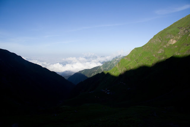
Shadow of one mountain on top of another on way to Shrikhand Mahadev
Kaali Ghati: This is a hill top, where we reach by crossing 4 hills after Thachru. All are 75 degree steep hills.
 View of Shrikhand Mahadev from Kaali Ghati: Shrikhand shivalingam can be clearly seen from Kaali ghati before 7:30 am. After that clouds cover the whole area and visibility radius reduces to 15 meters.
Bheem Dwari: Bheem Dwari is a beautiful valley on the way to Shrikhand Mahadev. It surrounded by lot of waterfalls from hills covered with snow.
 Wonderful waterfall view from Bheem Dwari..
 A small part of longest waterfall in Shrikhand Mahadev Trek...
Parvati Bag: Parvati Bag is a place where you see grass last time durin the trek to Shrikhand, the final destination. After this place Rock hills starts with clouds at ground level. So we were literally in clouds after Parvati Bag.

Clouds, and sunlight over a mountain on trek to Shrikhand Mahadev (This is morning view from Parvati Bag, when we started third say trek for our final destination: Shrikhand Mahadev)
 Pitched tent on way to Shrikhand Mahadev (We spent two nights in Parvati Bag)
 Sunlight coming through hill top : Wonderful view from Kali ghati
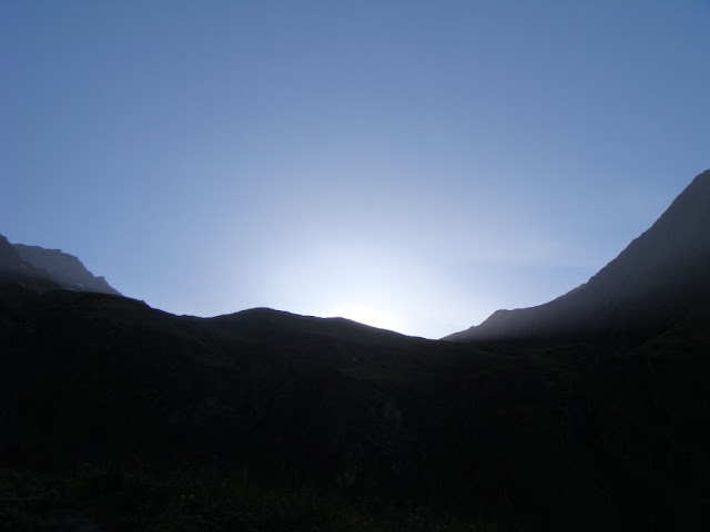 Sun light crossing though hills...
Nain Sarovar
 Mountain shadow convering Nain sarovar on the way to Shrikhand Mahadev...
 DHOLA RAM JI Porter enjoying a cigarette break on way to Shrikhand Mahadev
 Cloud Store @ Bheem Paudi (Strains to heaven)
 Fellow trekkers climbing rock hills between Nain Sarovar and Shrikhand Mahadev
Glaciers between Nain Sarovar and Shrikhand Mahadev...
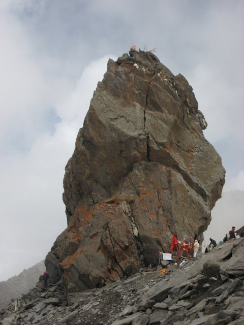 Rock-made shivalingam on the great heights of mountains. The shivalingam is 72 feet high and stands still at the mountain top, above 18,000 ft altitude.
Rock-made shivalingam on the great heights of mountains. The shivalingam is 72 feet high and stands still at the mountain top, above 18,000 ft altitude.Trip Details
More Pics
& More
Shrikhand Mahadev Trekking was an amazing experience for us and hope we will again go to this place with better planning...
More Pics
& More
Shrikhand Mahadev Trekking was an amazing experience for us and hope we will again go to this place with better planning...
Check out more photographs of Shrikhand Trekby clicking below mentioned links:

.jpg)
Comments
It was a great experience and I can't forget it...
Sun ke achha laga ki abhi bhi ye jagah vaisi hi hai jaisi maine 3 saal pehle dekhi thi...